Export Overture places to GeoJSON and CSV
The usual route to an Overture extract is to install DuckDB (or a plugin that needs it), query the GeoParquet files on S3 or Azure, and write the result out. That works, but it is a lot of setup when all you want is "every bakery in this neighbourhood, as a file I can open". With the Overture Maps API it's a few HTTP requests and a short script.
This guide exports every bakery within 800 m of Place des Vosges in Paris. Paris is one of the demo key's cities, so everything below runs as written with DEMO-API-KEY. Use your own key to export anywhere else.
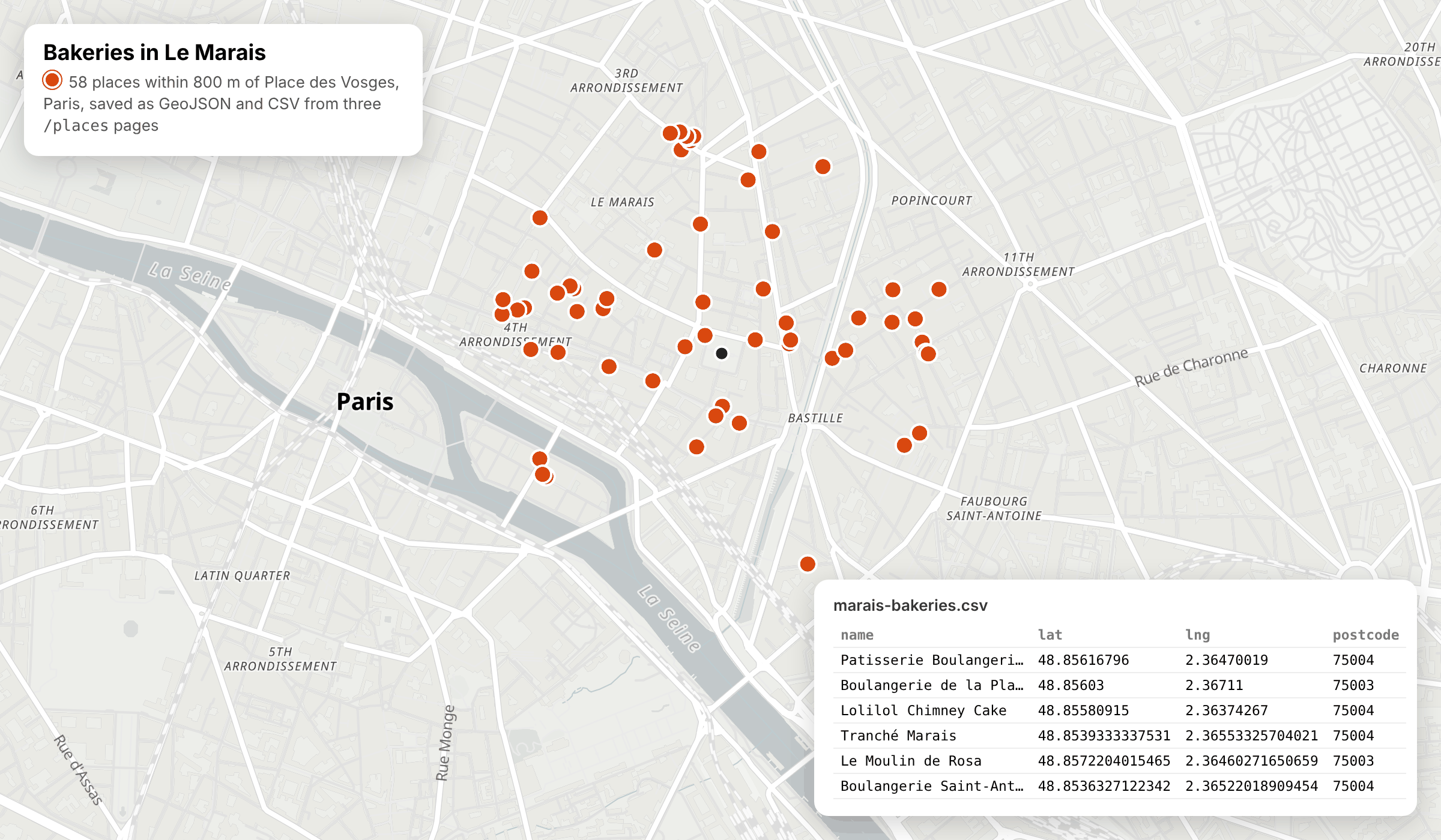
/places pages, saved as GeoJSON and CSV. Map: OpenFreeMap, © OpenMapTiles, data © OpenStreetMap contributors.
What you'll build
A small TypeScript script that:
- asks
/placesfor GeoJSON instead of plain JSON - pages through every result, however many pages there are
- trims each place down to the fields you need
- writes
marais-bakeries.geojsonfor GIS tools andmarais-bakeries.csvfor spreadsheets
Step 1: Ask for GeoJSON
Add format=geojson to any /places search and the response is a GeoJSON FeatureCollection instead of a bare array:
curl -i -H "x-api-key: DEMO-API-KEY" -X GET -G 'https://api.overturemapsapi.com/places' \
-d 'lat=48.8556' -d 'lng=2.3655' -d 'radius=800' -d 'categories=bakery' \
-d 'format=geojson' -d 'limit=25'
Pagination-Count: 58
Pagination-Page: 0
Pagination-Limit: 25
{
  "type": "FeatureCollection",
  "features": [
    {
      "type": "Feature",
      "id": "b9458638-3e3d-4dba-961d-b9729f87af59",
      "geometry": { "type": "Point", "coordinates": [2.36470019, 48.85616796] },
      "properties": {
        "names": { "primary": "Patisserie Boulangerie Mr Jacques" },
        "taxonomy": { "primary": "bakery", "hierarchy": ["food_and_drink", "casual_eatery", "bakery"] },
        "websites": ["http://patisseriemrjacques.com/"],
        "phones": ["+33183920019"],
        "addresses": [{ "freeform": "19 Pl. des Vosges", "locality": "Paris", "postcode": "75004", "country": "FR" }]
      }
    }
  ]
}
(Properties shortened here.) Pagination-Count tells you the total before you fetch anything else: 58 bakeries in this search. The same format=geojson works on /buildings and /transportation, so the rest of this guide applies to footprints and street segments too.
Step 2: Page through everything
One request returns one page. With 58 results and the demo key's page size of 25 (the demo key returns at most 25 per page, whatever limit you send), that's three pages: 25, 25 and 8. Keep requesting page=0, page=1 and so on until you have Pagination-Count features. See Pagination for the details.
type Feature = {
  type: "Feature";
  id: string;
  geometry: { type: "Point"; coordinates: [number, number] };
  properties: Record<string, any>;
};
type FeatureCollection = { type: "FeatureCollection"; features: Feature[] };

const API = "https://api.overturemapsapi.com/places";
const KEY = process.env.OVERTURE_API_KEY ?? "DEMO-API-KEY";

async function exportPlaces(filters: Record<string, string>): Promise<FeatureCollection> {
  const features: Feature[] = [];
  let total = Infinity;

  for (let page = 0; features.length < total; page++) {
    const params = new URLSearchParams({ ...filters, format: "geojson", page: String(page) });
    const res = await fetch(`${API}?${params}`, { headers: { "x-api-key": KEY } });
    if (!res.ok) throw new Error(`Page ${page} failed: ${res.status} ${await res.text()}`);

    total = Number(res.headers.get("Pagination-Count") ?? 0);
    const batch = (await res.json()) as FeatureCollection;
    if (batch.features.length === 0) break; // nothing left
    features.push(...batch.features);
  }

  return { type: "FeatureCollection", features };
}
The result is one FeatureCollection holding every page, ready to save. Every page is a normal request and counts towards your monthly allowance, so check Pagination-Count with a single small request before you export something large.
Step 3: Keep only the fields you need
A full place record carries sources, version numbers, brand objects and more. For an export you usually want a handful of fields. includes returns only the properties you list:
curl -H "x-api-key: DEMO-API-KEY" -X GET -G 'https://api.overturemapsapi.com/places' \
-d 'lat=48.8556' -d 'lng=2.3655' -d 'radius=800' -d 'categories=bakery' \
-d 'format=geojson' -d 'limit=25' -d 'includes=names,taxonomy,addresses,websites,phones'
For this first page of 25 bakeries, the response drops from 31,022 bytes to 12,895. Each feature keeps its id and geometry. Properties with no value are left out, so don't assume every key is present.
Step 4: Write GeoJSON and CSV files
GeoJSON can be saved as it comes. For a CSV, flatten each feature into one row: name, category, coordinates, the first address, website and phone. The API returns JSON and GeoJSON, so do this conversion on your side. (format=csv appears in the OpenAPI reference, but in our tests it currently returns JSON.)
import { writeFile } from "node:fs/promises";

const COLUMNS = ["id", "name", "category", "lat", "lng", "address", "postcode", "website", "phone"] as const;

function csvCell(value: unknown): string {
  const s = value == null ? "" : String(value);
  return /[",\n]/.test(s) ? `"${s.replaceAll('"', '""')}"` : s;
}

function toCsv(fc: FeatureCollection): string {
  const rows = fc.features.map(({ id, geometry, properties: p }) => {
    const [lng, lat] = geometry.coordinates;
    const address = p.addresses?.[0];
    return [
      id,
      p.names?.primary,
      p.taxonomy?.primary,
      lat,
      lng,
      address?.freeform,
      address?.postcode,
      p.websites?.[0],
      p.phones?.[0],
    ].map(csvCell).join(",");
  });
  return [COLUMNS.join(","), ...rows].join("\n") + "\n";
}

const places = await exportPlaces({
  lat: "48.8556",
  lng: "2.3655",
  radius: "800",
  categories: "bakery",
  limit: "25",
  includes: "names,taxonomy,addresses,websites,phones",
});

await writeFile("marais-bakeries.geojson", JSON.stringify(places));
await writeFile("marais-bakeries.csv", toCsv(places));
console.log(`Saved ${places.features.length} places`);
Put Steps 2 and 4 in one file called export-places.mts (the .mts extension lets Node treat it as a module, so top-level await works) and run it with Node 20 or later:
npx tsx export-places.mts
# Saved 58 places
GeoJSON coordinates are [lng, lat], which is why the code swaps them into separate lat and lng columns. The first rows of the CSV:
id,name,category,lat,lng,address,postcode,website,phone
b9458638-3e3d-4dba-961d-b9729f87af59,Patisserie Boulangerie Mr Jacques,bakery,48.85616796,2.36470019,19 Pl. des Vosges,75004,http://patisseriemrjacques.com/,+33183920019
fc8df7d3-3e70-41f9-abb5-a3ccb7b2c127,Boulangerie de la Place des Vosges Paris 03,bakery,48.85603,2.36711,6 Rue du Pas-de-la-Mule,75003,,+33157408385
4e1b71a1-e07a-411e-97ae-7ca607f7f9b4,Lolilol Chimney Cake,bakery,48.85580915,2.36374267,19 Rue de Turenne,75004,http://lolilolchimneycake.com/,+33782813550
Of the 58 bakeries, 47 have a website and 55 have a phone number. The id column is each place's GERS ID, so you can join the export back to Overture data later.
Step 5: Open the files
- QGIS: drag
marais-bakeries.geojsononto the map canvas, or use Layer → Add Layer → Add Vector Layer. No plugin and no DuckDB needed. - geojson.io or kepler.gl: drop the GeoJSON file onto the page to see the points on a map.
- Excel, Numbers or Google Sheets: open or import
marais-bakeries.csv. Postcodes and phone numbers are plain text in the file, but some spreadsheet apps reformat them on import, so set those columns to text if leading zeros matter.
Going further
- Export a different slice. Swap
categories=bakeryfor any other filter on/places:taxonomy=food_and_drinkfor every place to eat and drink,brand_namefor one chain (see Map every location of a retail chain), orhas_contact=websiteto keep only places with a website. - Find what's worth exporting. Profile a neighbourhood uses
/places/categoriesto count every category in a radius first. - Export footprints instead of points.
/buildingstakes the sameformat=geojson,includesand paging. - Whole countries. On a paid plan, replace
lat,lngandradiuswithcountryplus a narrowing filter, and use a largerlimit. See Usage limits.